|
|
|||
 Sacsayhuamán
‡ Pisac ‡ Inca Trail
‡ Sacsayhuamán
‡ Pisac ‡ Inca Trail
‡ Patallaqta ‡ Runkurakay ‡ Sayaqmarka ‡ Wiñaywayna ‡ Machu Picchu |
|||
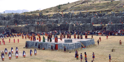 Sacsayhuamán SacsayhuamánI inadvertently hiked up to Sacsayhuamán when taking the wrong road up to Albergue Municipal. As the first Incan site I visited, Sacsayhuamán impressed me with its large terraces facing Cuzco, well-made stone road leading down to Cuzco, and massive, perfectly fitted stone walls. Sacsayhuamán is a perfect example of the Inca's placement of fortresses and religious structures on apus, or mountain peaks, where they can overlook and protect the settlement below, as well as provide ceremonial centers on the sacred mountain tops. The zigzag, tiered walls would have been difficult for any opponent to attack. As with most Incan sites, however, the Spaniards destroyed much of Sacsayhuamán long before archeologists ever saw it. |
|||
|
|
|||
|
|
|||
|
|
|||
|
Inca Trail By hiking this trail, I gained a deep respect for Incan engineers and surveyors. The routes the road took were difficult enough to hike as it was, but the alternatives were clearly worse. It must have taken a lot of long, hard work to plan such a winding, clever road. It would down into the cloud and rainforest and climb up past the tree line to make it through high passes. At one point, the engineers tunneled through the mountainside and at others, a massive terrace was built against the cliff. Physically walking the trail gave me appreciation for how the Incas both regulated people traveling on their roads and gave them hospitality. The famous way posts were placed so that they could view important river valleys and mountain passes, enabling them to know someone was coming at least a half hour before they arrived. Also, they were placed so that no matter where you were on the trail, you should be able to get to one of them in a half-day's hike. Larger administrative stations were available within full day's hike, and offered places for the llamas, chicha, and irrigated ceremonial fountains. |
|||
|
|
|||
|
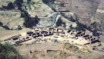
Patallaqta 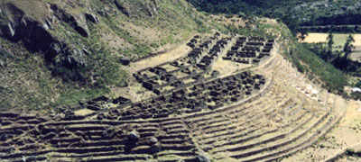
|
|||
|
|
|||
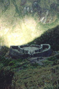 Runkurakay RunkurakayThe next site I visited, Runkurakay, was little more than a half-circle fort where travelers could stay in an emergency and a small garrison could keep watch over the two highest passes of the trail: Abra de Warmiwañusqa and Abra de Runkurakay. Runkurakay lacked irrigation and terraces, so a garrison probably temporarily manned it, rather than anyone subsisting there permanently. |
|||
|
|
|||
| Sayaqmarka Sayaqmarka was the first clear example of the classic Incan way post I saw. It had enough terraces and irrigation to support a very small resident population, three fountains for visitors to wash in, an open entrance area for llamas, and a several different rooms for either travelers or army personnel. Similar to Runkurakay, the site was placed at an important location on the trail, where you could see the pass approaching it as well as the valley below. 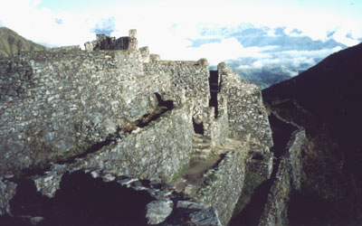 The
two most impressive elements of this site were the irrigation, which crossed
a gap in the mountain by a wooden aqueduct (obviously restored, but still
ingenious), and ran through the site on walls and through the floors;
and the amount of work the Incas put into building additional terraces
on very steep mountainside, to which you could only access by flagstone
steps sticking out of the terrace above. The
two most impressive elements of this site were the irrigation, which crossed
a gap in the mountain by a wooden aqueduct (obviously restored, but still
ingenious), and ran through the site on walls and through the floors;
and the amount of work the Incas put into building additional terraces
on very steep mountainside, to which you could only access by flagstone
steps sticking out of the terrace above. |
|||
|
|
|||
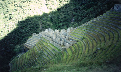 Wiñaywayna WiñaywaynaThe last site I visited before Machu Picchu was Wiñaywayna. This site had agricultural terraces to rival Pisac and like Pisac, just one very narrow staircase to access them. The architecture was centered on the far side of the terraces, vertically aligned to the middle of them. Irrigation supplied water to a series of fountains flowing down the terraces to the site, beside the staircase. There were plenty of residences for a small permanent population, typical accommodations for travelers, and a decent view of the surrounding valley. 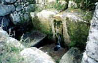 This site did not seem to be located as much for regulation of the roads,
since it was slightly offset downhill from the road, and did not have
a commanding view of important passes. Instead, it may have helped to
supply Machu Picchu with agricultural products.
This site did not seem to be located as much for regulation of the roads,
since it was slightly offset downhill from the road, and did not have
a commanding view of important passes. Instead, it may have helped to
supply Machu Picchu with agricultural products. |
|||
|
|
|||
|
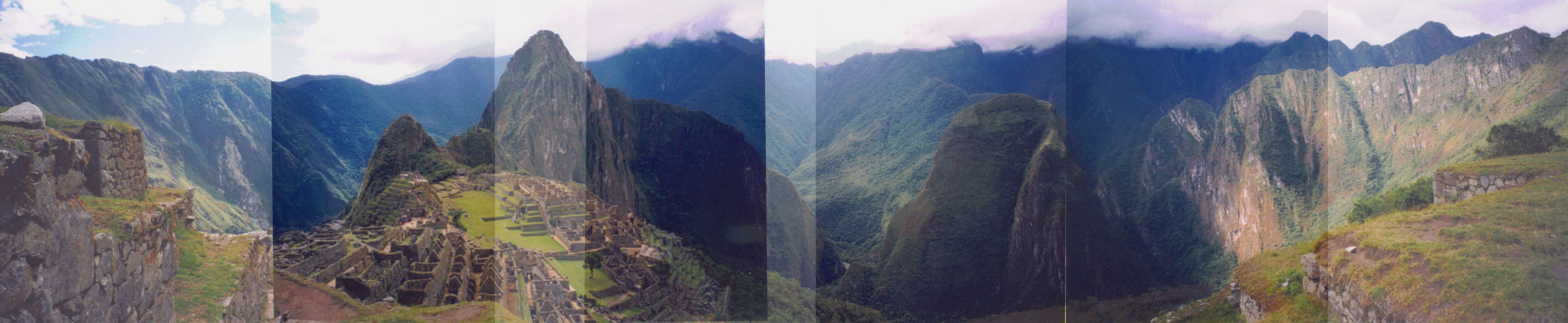
Machu Picchu
At the time the Incas abandoned Machu Picchu, they were building another site near the top of Huayna Picchu, and had completed a trail through a cave to the peak, a couple residential structures, and some terraces and stairs. Considering the amount of time and energy the Inca put into the Intihuatana, the highest peak of the city itself, I can only imagine what they might have planned for Huayna Picchu. Before leaving Machu Picchu, I was able to explore the acoustics of the plazas, from which you can clearly hear a speaker orating in a normal tone of voice from the platform high above. I also explored the extensive residential buildings opposite the plazas from the ceremonial centers, but they were no more spectacular than those at Pisac or Wiñaywayna. Click the picture below to see the view from the Hut
of the Caretaker of the Funerary Rock: |
|||
|
|
|||
 Pisac
Pisac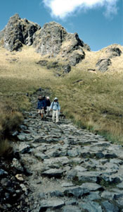 The
road was anything but flat, with long sections of gently sloped steps,
and paved with uneven stones.
The
road was anything but flat, with long sections of gently sloped steps,
and paved with uneven stones.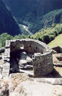 Machu
Picchu's important ceremonial centers include the Sun Temple, which
has an uneven stone altar and two precisely cut windows for determining
equinoxes, under which a natural cave was carved to create the Royal
Tomb. Above this is a plaza containing an elite residence, the Sacristy,
and the Temple of the Three Windows, accurately named for three windows
looking out on the Urubamba River Valley. Intihuatana, about 70 steps
above the plaza, is the highest, and probably most important shrine
in Machu Picchu. The center of Intihuatana is an altar carved out of
the bedrock of the mountain, the highest point of which makes a sort
of sundial for determining the time of year. The whole altar looks deceptively
simple and natural, but apparently all of its corners and slopes are
astronomically aligned.
Machu
Picchu's important ceremonial centers include the Sun Temple, which
has an uneven stone altar and two precisely cut windows for determining
equinoxes, under which a natural cave was carved to create the Royal
Tomb. Above this is a plaza containing an elite residence, the Sacristy,
and the Temple of the Three Windows, accurately named for three windows
looking out on the Urubamba River Valley. Intihuatana, about 70 steps
above the plaza, is the highest, and probably most important shrine
in Machu Picchu. The center of Intihuatana is an altar carved out of
the bedrock of the mountain, the highest point of which makes a sort
of sundial for determining the time of year. The whole altar looks deceptively
simple and natural, but apparently all of its corners and slopes are
astronomically aligned.